
Make a donation
Guiyang topographic map
Click on the map to display elevation.
Make a donation
Guiyang
Guiyang is the capital of Guizhou province in the People's Republic of China. It is centrally located within the province, on the eastern part of the Yunnan–Guizhou Plateau, and sits on the north bank of the Nanming River, a tributary of the Wu River. The city is situated at an elevation of approximately 1,100 meters (3,600 ft) and covers an area of 8,034 square kilometers (3,102 sq mi). According to the 2020 census, Guiyang had a total population of 5,987,018, with 4,506,134 lived in its six urban districts. Despite being the capital of Guizhou, it is not the largest city in the province, which is Zunyi.
Make a donation
About this map
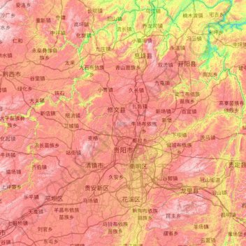
Name: Guiyang topographic map, elevation, terrain.
Location: Guiyang, Guizhou, China (26.18678 106.11897 27.35999 107.27469)
Average elevation: 1,209 m
Minimum elevation: 525 m
Maximum elevation: 1,906 m
Make a donation
Other topographic maps
Click on a map to view its topography, its elevation and its terrain.
Fanjing Mountain
China > Guizhou > Yinjiang Tujia and Miao Autonomous County
The Fanjingshan (Chinese: 梵净山; pinyin: Fànjìngshān) or Mount Fanjing, located in Tongren, Guizhou province, is the highest peak of the Wuling Mountains in southeastern China, at an elevation of 2,570 m (8,430 ft). The Fanjingshan National Nature Reserve was established in 1978 and designated a UNESCO…
Average elevation: 2,054 m
Make a donation
Make a donation
Make a donation
Make a donation
Fanjingshan
The Fanjingshan (Chinese: 梵净山; pinyin: Fànjìngshān) or Mount Fanjing, located in Tongren, Guizhou province, is the highest peak of the Wuling Mountains in southwestern China, at an elevation of 2,570 m (8,430 ft). The Fanjingshan National Nature Reserve was established in 1978 and designated a UNESCO…
Average elevation: 1,958 m
Make a donation
Make a donation
Make a donation
Shandong
China > Guizhou > Qiandongnan Miao and Dong Autonomous Prefecture > Shandong
Average elevation: 1,000 m
Yinjiang
China > Guizhou > Yinjiang Tujia and Miao Autonomous County > Yinjiang
Average elevation: 787 m
Make a donation
Bijie
Bijie borders Zunyi to the east, Anshun and Liupanshui to the south, Zhaotong and Qujing (Yunnan) to the west, and Luzhou (Sichuan) to the north. It spans latitude 26°21′−27°46′ N and longitude 105°36′−106°43′ E, and is marked heavily by the presence of the Wumeng Mountains (乌蒙山) as well…
Average elevation: 1,651 m