
Thank you for supporting this site ❤️
Make a donation
Make a donation
Munyaka topographic map
Click on the map to display elevation.
Thank you for supporting this site ❤️
Make a donation
Make a donation
About this map
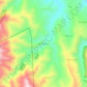
Name: Munyaka topographic map, elevation, terrain.
Location: Munyaka, Elementeita ward, Gilgil, Nakuru, Kenya (-0.66739 36.08405 -0.62739 36.12405)
Average elevation: 2,343 m
Minimum elevation: 2,117 m
Maximum elevation: 2,655 m
Thank you for supporting this site ❤️
Make a donation
Make a donation