
Make a donation
Dinas Dinlle topographic map
Click on the map to display elevation.
Make a donation
About this map
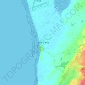
Name: Dinas Dinlle topographic map, elevation, terrain.
Location: Dinas Dinlle, Gwynedd, Wales, LL54 5TW, United Kingdom (53.06452 -4.35407 53.10452 -4.31407)
Average elevation: 7 m
Minimum elevation: -1 m
Maximum elevation: 64 m
Make a donation
Other topographic maps
Click on a map to view its topography, its elevation and its terrain.
Make a donation
Make a donation
Make a donation
Make a donation
Make a donation
Make a donation
Parc Tan-y-Bwlch
United Kingdom > Wales > Gwynedd > Mynydd Llandygái > Pen Y Bwlch
Average elevation: 293 m
Make a donation
Carneddau
United Kingdom > Wales > Gwynedd > Abergwyngregyn
The plants growing on the Carneddau need to be extremely hardy to withstand the snow, frosts, and gales they will encounter during the year and those found by sheltered streams in the valleys are very different from those clinging to crevices on windswept rocks. Sheep graze the mountains and impact the…
Average elevation: 408 m
Make a donation
Make a donation
Make a donation
Make a donation
Morfa Harlech National Nature Reserve
United Kingdom > Wales > Gwynedd > Harlech
Average elevation: 3 m
Make a donation
Make a donation
Make a donation
Make a donation
Make a donation