
Thank you for supporting this site ❤️
Make a donation
Make a donation
Tredegar topographic map
Click on the map to display elevation.
Thank you for supporting this site ❤️
Make a donation
Make a donation
About this map
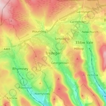
Name: Tredegar topographic map, elevation, terrain.
Location: Tredegar, Blaenau Gwent, Wales, NP22 3PX, United Kingdom (51.73326 -3.28695 51.81326 -3.20695)
Average elevation: 373 m
Minimum elevation: 202 m
Maximum elevation: 565 m
Thank you for supporting this site ❤️
Make a donation
Make a donation
Other topographic maps
Click on a map to view its topography, its elevation and its terrain.