
Make a donation
Giurtelecu Hododului topographic map
Click on the map to display elevation.
Make a donation
About this map
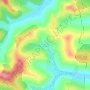
Name: Giurtelecu Hododului topographic map, elevation, terrain.
Location: Giurtelecu Hododului, Hodod, Satu Mare, 447156, Romania (47.39655 23.07295 47.43655 23.11295)
Average elevation: 239 m
Minimum elevation: 187 m
Maximum elevation: 317 m
Make a donation
Other topographic maps
Click on a map to view its topography, its elevation and its terrain.
Satu Mare
Satu Mare is situated in Satu Mare County, in northwest Romania, on the river Someș, 13 km (8.1 mi) from the border with Hungary and 27 km (17 mi) from the border with Ukraine. The city is located at an altitude of 126 m (413 ft) on the Lower Someș alluvial plain, spreading out from the Administrative Palace…
Average elevation: 124 m
Make a donation
Make a donation
Tarna Mare
Tarna Mare is situated in the Țara Oașului ethnocultural and historical region in the extreme north of Satu Mare County. It lies at an altitude of 168 m (551 ft), on the banks of the river Tarna Mare. The commune is located 54 km (34 mi) northeast of the county seat, Satu Mare, on the border with Ukraine.
Average elevation: 292 m
Satu Mare
Satu Mare is situated in Satu Mare County, in northwest Romania, on the river Someș, 13 km (8.1 mi) from the border with Hungary and 27 km (17 mi) from the border with Ukraine. The city is located at an altitude of 126 m (413 ft) on the Lower Someș alluvial plain, spreading out from the Administrative Palace…
Average elevation: 124 m
Make a donation
Satu Mare
Satu Mare is situated in Satu Mare County, in northwest Romania, on the river Someș, 13 km (8.1 mi) from the border with Hungary and 27 km (17 mi) from the border with Ukraine. The city is located at an altitude of 126 m (413 ft) on the Lower Someș alluvial plain, spreading out from the Administrative Palace…
Average elevation: 124 m