
Make a donation
Mumbai topographic map
Click on the map to display elevation.
Make a donation
Mumbai
Mumbai lies at the mouth of the Ulhas River on the western coast of India, in the coastal region known as the Konkan. It sits on Salsette Island (Sashti Island), which it partially shares with the Thane district. Mumbai is bounded by the Arabian Sea to the west. Many parts of the city lie just above sea level, with elevations ranging from 10 to 15 metres (33 to 49 ft). The city has an average elevation of 14 metres (46 ft). Northern Mumbai (Salsette) is hilly, and the highest point in the city is 450 metres (1,480 ft) at Salsette in the Powai–Kanheri ranges. The Sanjay Gandhi National Park (Borivali National Park) is situated partly in the Mumbai suburban district and partly in the Thane district, covering an area of 103.09 square kilometres (39.80 sq mi).
Make a donation
About this map
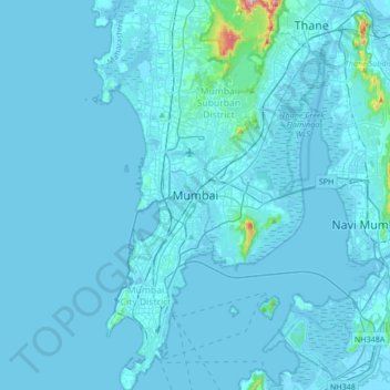
Name: Mumbai topographic map, elevation, terrain.
Location: Mumbai, Mumbai Suburban District, Maharashtra, 400051, India (18.89500 72.70920 19.21500 73.02920)
Average elevation: 13 m
Minimum elevation: -4 m
Maximum elevation: 460 m
Make a donation
Other topographic maps
Click on a map to view its topography, its elevation and its terrain.
Mumbai
India > Maharashtra > Mumbai
Mumbai is on a narrow peninsula on the southwest of Salsette Island, which lies between the Arabian Sea to the west, Thane Creek to the east and Vasai Creek to the north. Mumbai's suburban district occupies most of the island. Navi Mumbai is east of Thane Creek and Thane is north of Vasai Creek. Mumbai…
Average elevation: 18 m
Pune City
Pune lies on the western margin of the Deccan plateau, at an altitude of 560 m (1,840 ft) above sea level. It is on the leeward side of the Sahyadri mountain range, which forms a barrier from the Arabian Sea. It is a hilly city, with Vetal Hill rising to 800 m (2,600 ft) above sea level. The Sinhagad fort is…
Average elevation: 616 m
Mumbai
Mumbai is on a narrow peninsula on the southwest of Salsette Island, which lies between the Arabian Sea to the west, Thane Creek to the east and Vasai Creek to the north. Mumbai's suburban district occupies most of the island. Navi Mumbai is east of Thane Creek and Thane is north of Vasai Creek. Mumbai…
Average elevation: 18 m
Make a donation
Nanded District
Nanded is bounded on the north by Yavatmal district of the Vidarbha region, with Latur on south-west, Parbhani and Hingoli districts on the west. On the eastern side lies Adilabad, Nirmal, Nizamabad and Kamareddy districts of Telangana state, and on the south lies Bidar of Karnataka state. The area presents…
Average elevation: 432 m
Latur District
Latur district is in the Marathwada region in Maharashtra in India, located between 17°52' North to 18°50' North and 76°18' East to 79°12' East in the Deccan plateau. It has an average elevation of 631 metres (2,070 ft) above mean sea level. The entire district of Latur is on the Balaghat plateau, 540 to…
Average elevation: 590 m
Make a donation
Make a donation
Paithan
Paithan is located at 19°29′N 75°23′E / 19.48°N 75.38°E / 19.48; 75.38. It has an average elevation of 458 m (1,503 ft).
Average elevation: 495 m
Make a donation
Ratnagiri
An outstanding feature of the geography of the district is its uneven or hill topography, with about 45% of the district being characterized as 'hilly'. Very narrow riverine plains fringe the coastline.
Average elevation: 301 m
Make a donation
Make a donation
Panhala
Panhala is located at 16°49′12″N 74°7′12″E / 16.82000°N 74.12000°E / 16.82000; 74.12000. It has an average elevation of 754 metres (2473 feet). Panhala is connected via train and bus to Kolhapur and Sangli. Kolhapur is about 21 km away while Sangli is about 60 km. Kolhapur Chhatrapati…
Average elevation: 620 m
Make a donation
Make a donation
Nashik District
The entire Nashik district is underlain by the basaltic lava flows. These flows are normally horizontally disposed over a wide stretch and give rise to table land type of topography also known as a plateau. These flows occur in layered sequences and represented by massive unit at the bottom and vesicular unit…
Average elevation: 522 m
Bramhapuri Town
India > Maharashtra > Brahmapuri Taluka
Bramhapuri is one of the six divisions located in the northeastern part of Chandrapur district, Maharashtra at 20°22′N 79°31′E / 20.36°N 79.51°E / 20.36; 79.51 and has an average elevation of 229.5 metres (753 feet). The town is located in the 73rd Vidhan Sabha constituency in Maharashtra.
Average elevation: 226 m
Navi Mumbai
India > Maharashtra > Thane Subdistrict
Navi Mumbai (Marathi pronunciation: [nəʋiː mumbəiː]), is a planned city situated on the west coast of the Indian subcontinent, located in the Konkan division of Maharashtra state, on the mainland of India. Navi Mumbai is part of the Mumbai Metropolitan Region (MMR). The city is divided into two, North…
Average elevation: 22 m
Make a donation
Make a donation
Pune
Pune is situated at approximately 18° 32" north latitude and 73° 51" east longitude. The city's total area is 15.642 km2, and the municipal corporation area covers 518 km2. By road Pune is 149 km (93 mi) south-east of Mumbai, 580 km (360 mi) south-west of Indore, 695 km (432 mi) west of Nagpur, 1,173 km (729…
Average elevation: 616 m
Kolhapur District
Kolhapur experiences winter from November to February. The winter temperatures are warmer than other cities in Maharashtra such as Pune and Nashik. Lows range from 9 to 16 °C (48 to 61 °F) while highs are in the range of 24 to 32 °C (75 to 90 °F) due to its high elevation and being adjacent to the Western…
Average elevation: 464 m
Chikhaldara
The sole hill resort in the Vidarbha region, it is situated at an altitude of 1118 meters with highest elevation point 1188 meters and has the added dimension of being the only coffee-growing area in Maharashtra. Chikhaldara has an annual rainfall of 154cm. Temperatures vary from 39C in summer to 5C in winter.…
Average elevation: 521 m
Make a donation
Make a donation
Make a donation
Make a donation
Buldhana District
Lonarkar Top (about 923 meters) is highest altitude in Buldhana District placed in Ambabarwa Wildlife Sanctuary.
Average elevation: 425 m
Pune City
Pune lies on the western margin of the Deccan plateau, at an altitude of 560 m (1,840 ft) above sea level. It is on the leeward side of the Sahyadri mountain range, which forms a barrier from the Arabian Sea. It is a hilly city, with Vetal Hill rising to 800 m (2,600 ft) above sea level. The Sinhagad fort is…
Average elevation: 616 m
Make a donation
Make a donation
Make a donation
Make a donation
Make a donation
Make a donation
Make a donation
Make a donation
Kagal
Kagal is a taluka in Kolhapur district. It is located at the boundary of Maharashtra and Karnataka. The Chhatrapati Shahu Sahakari Sakar Karkhana is located here. The Dudhganga river passes through Kagal. Kagal is located at 16°35′N 74°19′E / 16.58°N 74.32°E / 16.58; 74.32. It has an average…
Average elevation: 607 m
Make a donation
Pune District
The district is surrounded by Thane district on the northwest, Raigad district on the west, Satara district on the south, Solapur district on the southeast, and Ahmednagar district on the north and northeast. On the leeward side of the Western Ghats, it extends to the Deccan Plateau on the east. Pune is at an…
Average elevation: 520 m
Make a donation
Make a donation