
Thank you for supporting this site ❤️
Make a donation
Make a donation
Dumfries and Galloway topographic map
Click on the map to display elevation.
Thank you for supporting this site ❤️
Make a donation
Make a donation
About this map
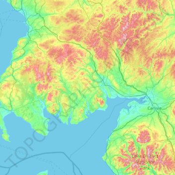
Name: Dumfries and Galloway topographic map, elevation, terrain.
Location: Dumfries and Galloway, Scotland, United Kingdom (54.63324 -5.18765 55.46405 -2.85733)
Average elevation: 163 m
Minimum elevation: -1 m
Maximum elevation: 921 m
Thank you for supporting this site ❤️
Make a donation
Make a donation
Other topographic maps
Click on a map to view its topography, its elevation and its terrain.
Ben Nevis
United Kingdom > Scotland > Highland
Ben Nevis has a highland tundra climate (ET in the Köppen classification). Ben Nevis's elevation, maritime location and topography frequently lead to cool and cloudy weather conditions, which can pose a danger to ill-equipped walkers. According to the observations carried out at the summit observatory from…
Average elevation: 912 m