
Cedarville topographic map
Interactive map
Click on the map to display elevation.
About this map
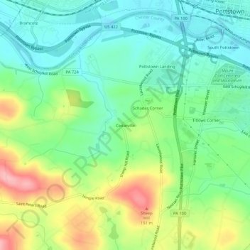
Name: Cedarville topographic map, elevation, terrain.
Average elevation: 82 m
Minimum elevation: 36 m
Maximum elevation: 168 m
Other topographic maps
Click on a map to view its topography, its elevation and its terrain.
Pottstown Landing
United States > Pennsylvania > Chester County > North Coventry Township
Pottstown Landing, North Coventry Township, Chester County, Pennsylvania, 19465, United States
Average elevation: 66 m
South Pottstown
United States > Pennsylvania > Chester County > North Coventry Township
South Pottstown, North Coventry Township, Chester County, Pennsylvania, 19465, United States
Average elevation: 61 m
Kenilworth
United States > Pennsylvania > Chester County > North Coventry Township
Kenilworth, North Coventry Township, Chester County, Pennsylvania, 19464, United States
Average elevation: 61 m
North Coventry Township
United States > Pennsylvania > Chester County > North Coventry Township
North Coventry Township, Chester County, Pennsylvania, 19465, United States
Average elevation: 108 m