
Thank you for supporting this site ❤️
Make a donation
Make a donation
Roxbury topographic map
Click on the map to display elevation.
Thank you for supporting this site ❤️
Make a donation
Make a donation
About this map
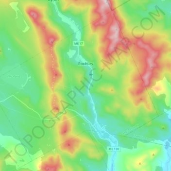
Name: Roxbury topographic map, elevation, terrain.
Location: Roxbury, Oxford County, Maine, 04275, United States (44.59081 -70.70644 44.71320 -70.51060)
Average elevation: 379 m
Minimum elevation: 145 m
Maximum elevation: 834 m
Thank you for supporting this site ❤️
Make a donation
Make a donation
Other topographic maps
Click on a map to view its topography, its elevation and its terrain.
Thank you for supporting this site ❤️
Make a donation
Make a donation
Thank you for supporting this site ❤️
Make a donation
Make a donation