
Thank you for supporting this site ❤️
Make a donation
Make a donation
High Falls topographic map
Click on the map to display elevation.
Thank you for supporting this site ❤️
Make a donation
Make a donation
About this map
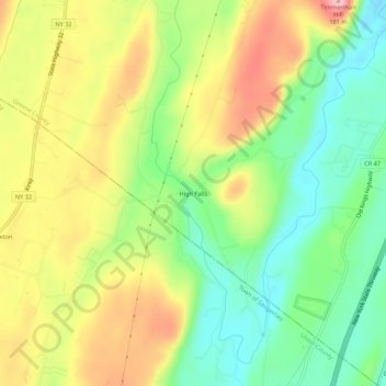
Name: High Falls topographic map, elevation, terrain.
Average elevation: 90 m
Minimum elevation: 21 m
Maximum elevation: 174 m
Thank you for supporting this site ❤️
Make a donation
Make a donation
Other topographic maps
Click on a map to view its topography, its elevation and its terrain.
Catskill Forest Preserve Detatched Parcel
United States > New York > Greene County > Town of Catskill
Average elevation: 65 m