
Bloomfield topographic map
Interactive map
Click on the map to display elevation.
About this map
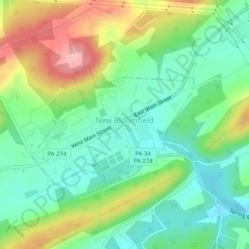
Name: Bloomfield topographic map, elevation, terrain.
Location: Bloomfield, Perry County, Pennsylvania, United States (40.41275 -77.20040 40.42578 -77.17727)
Average elevation: 236 m
Minimum elevation: 183 m
Maximum elevation: 330 m
Other topographic maps
Click on a map to view its topography, its elevation and its terrain.
Duncannon
United States > Pennsylvania > Perry County
Duncannon, Perry County, Pennsylvania, United States
Average elevation: 138 m
Liverpool
United States > Pennsylvania > Perry County
Liverpool, Perry County, Pennsylvania, 17045, United States
Average elevation: 148 m
Loysville
United States > Pennsylvania > Perry County > Loysville
Loysville, Perry County, Pennsylvania, 17047, United States
Average elevation: 197 m
Buffalo Mountain
United States > Pennsylvania > Perry County
Buffalo Mountain, Perry County, Pennsylvania, United States
Average elevation: 250 m
New Bloomfield
United States > Pennsylvania > Perry County > New Bloomfield
New Bloomfield, Perry County, Pennsylvania, 17068, United States
Average elevation: 238 m
Shermans Dale
United States > Pennsylvania > Perry County
Shermans Dale, Perry County, Pennsylvania, 17090, United States
Average elevation: 171 m