
Make a donation
Aztec topographic map
Click on the map to display elevation.
Make a donation
Aztec
Yet another area managed by the BLM, this area was formed about the same time as the Bisti and Ah-Shi-Sle-Pah. This region offers a uniquely different scale of landscape. Hoodoo in this region are massive and the terrain much greater in elevation differences, thereby exposing a greater geological time frame than the Bisti or Ah-Shi-Sle-Pah. This region is a bit more accessible due to oil field roads traversing the region. However, extreme caution is required when driving on as these roads as they are impassible when wet.
Make a donation
About this map
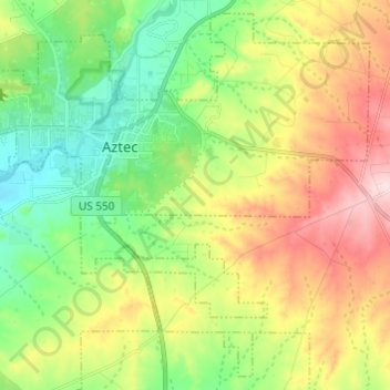
Name: Aztec topographic map, elevation, terrain.
Location: Aztec, San Juan County, New Mexico, United States (36.76484 -108.03648 36.85535 -107.91504)
Average elevation: 1,803 m
Minimum elevation: 1,692 m
Maximum elevation: 1,974 m
Make a donation
Other topographic maps
Click on a map to view its topography, its elevation and its terrain.
El Paso Natural Gas Dam Number 5
United States > New Mexico > San Juan County > Kirtland
Average elevation: 1,604 m
Make a donation
Make a donation