
Thank you for supporting this site ❤️
Make a donation
Make a donation
Cabeza de Caballo topographic map
Click on the map to display elevation.
Thank you for supporting this site ❤️
Make a donation
Make a donation
About this map
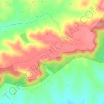
Name: Cabeza de Caballo topographic map, elevation, terrain.
Location: Cabeza de Caballo, Cáceres, Extremadura, España (39.22420 -6.73387 39.24420 -6.71387)
Average elevation: 321 m
Minimum elevation: 273 m
Maximum elevation: 366 m
Thank you for supporting this site ❤️
Make a donation
Make a donation
Other topographic maps
Click on a map to view its topography, its elevation and its terrain.