
Thank you for supporting this site ❤️
Make a donation
Make a donation
Ambingue topographic map
Click on the map to display elevation.
Thank you for supporting this site ❤️
Make a donation
Make a donation
About this map
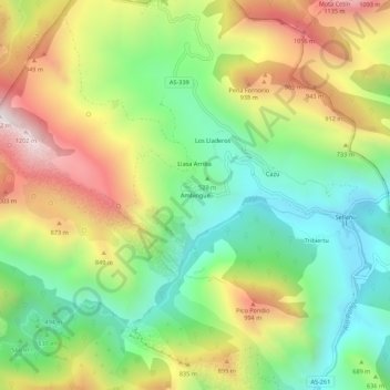
Name: Ambingue topographic map, elevation, terrain.
Location: Ambingue, Ponga, Asturias, España (43.24007 -5.24251 43.28007 -5.20251)
Average elevation: 627 m
Minimum elevation: 221 m
Maximum elevation: 1,199 m
Thank you for supporting this site ❤️
Make a donation
Make a donation
Other topographic maps
Click on a map to view its topography, its elevation and its terrain.