
Thank you for supporting this site ❤️
Make a donation
Make a donation
Hillary Step topographic map
Click on the map to display elevation.
Thank you for supporting this site ❤️
Make a donation
Make a donation
Hillary Step
The step was named after Sir Edmund Hillary, who partnered with Sherpa Tenzing Norgay, on 29 May 1953 climbing the crack between the snow and the rock, earning the feature its name. Upon completion of the summit, the pair reported the snowpack on Hillary is harder than that of lower elevation.
Thank you for supporting this site ❤️
Make a donation
Make a donation
About this map
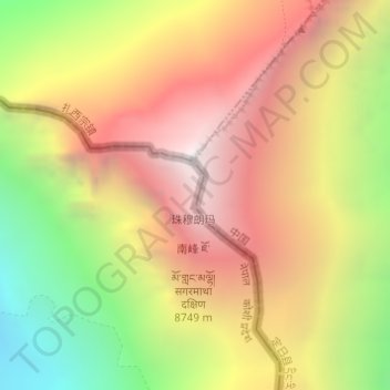
Name: Hillary Step topographic map, elevation, terrain.
Average elevation: 7,824 m
Minimum elevation: 6,597 m
Maximum elevation: 8,849 m
Thank you for supporting this site ❤️
Make a donation
Make a donation
Other topographic maps
Click on a map to view its topography, its elevation and its terrain.