
朗乡镇 topographic map
Interactive map
Click on the map to display elevation.
About this map
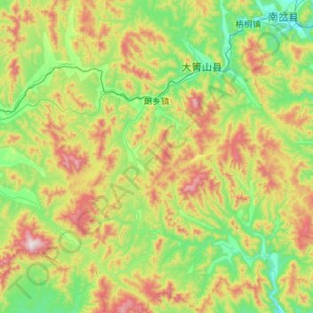
Name: 朗乡镇 topographic map, elevation, terrain.
Location: 朗乡镇, 大箐山县, 伊春市, 黑龙江省, 153000, 中国 (46.48077 128.54979 47.17087 129.39816)
Average elevation: 503 m
Minimum elevation: 156 m
Maximum elevation: 1,425 m
Other topographic maps
Click on a map to view its topography, its elevation and its terrain.