
Make a donation
Town of Brant topographic map
Click on the map to display elevation.
Make a donation
About this map
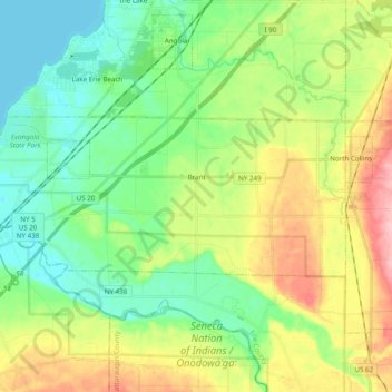
Name: Town of Brant topographic map, elevation, terrain.
Location: Town of Brant, Erie County, New York, United States (42.55193 -79.13831 42.61049 -78.94338)
Average elevation: 223 m
Minimum elevation: 172 m
Maximum elevation: 321 m
Make a donation
Other topographic maps
Click on a map to view its topography, its elevation and its terrain.
Erie Canal
United States > New York > Erie County > City of Tonawanda
The construction of the Erie Canal was a landmark civil engineering achievement in the early history of the United States. When built, the 363-mile (584 km) canal was the second-longest in the world (after the Grand Canal in China). Initially 40 feet (12 m) wide and 4 feet (1.2 m) deep, the canal was expanded…
Average elevation: 177 m
Make a donation
Make a donation
Mount Vernon
United States > New York > Erie County > Town of Hamburg > Wanakah
Average elevation: 189 m
Make a donation
Make a donation
Make a donation
Clifton Heights
United States > New York > Erie County > Town of Hamburg > Wanakah
Average elevation: 195 m
Make a donation
Make a donation
Make a donation
Green Acres Valley
United States > New York > Erie County > Town of Tonawanda
Average elevation: 178 m
Webster Corners
United States > New York > Erie County > Town of Orchard Park
Average elevation: 244 m
Make a donation
Make a donation
Make a donation
Make a donation
Make a donation
Make a donation
Make a donation
Eighteen Mile Creek (Erie County)
United States > New York > Erie County > Highland-on-the-Lake
Average elevation: 194 m
Make a donation
Lakeview Road Town Recreation Area
United States > New York > Erie County > Town of Hamburg
Average elevation: 231 m
Make a donation
Onondaga Escarpment
United States > New York > Erie County > Harris Hill > Town of Clarence > Eastern Hills
Average elevation: 205 m
Make a donation
Make a donation