
Thank you for supporting this site ❤️
Make a donation
Make a donation
South Brunswick topographic map
Click on the map to display elevation.
Thank you for supporting this site ❤️
Make a donation
Make a donation
About this map
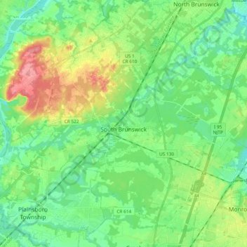
Name: South Brunswick topographic map, elevation, terrain.
Location: South Brunswick, Middlesex County, New Jersey, United States (40.32846 -74.62388 40.44138 -74.43684)
Average elevation: 36 m
Minimum elevation: 6 m
Maximum elevation: 102 m
Thank you for supporting this site ❤️
Make a donation
Make a donation
Other topographic maps
Click on a map to view its topography, its elevation and its terrain.
Pine Ridge Park
United States > New Jersey > Middlesex County > East Brunswick Township
Average elevation: 17 m