
Thank you for supporting this site ❤️
Make a donation
Make a donation
Tottenham topographic map
Click on the map to display elevation.
Thank you for supporting this site ❤️
Make a donation
Make a donation
About this map
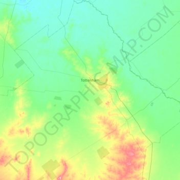
Name: Tottenham topographic map, elevation, terrain.
Average elevation: 221 m
Minimum elevation: 185 m
Maximum elevation: 361 m
Thank you for supporting this site ❤️
Make a donation
Make a donation
Other topographic maps
Click on a map to view its topography, its elevation and its terrain.
Wolongong Hill
Australia > New South Wales > Lachlan Shire Council > Condobolin
Average elevation: 199 m
Wolongong Hill
Australia > New South Wales > Lachlan Shire Council > Condobolin
Average elevation: 199 m