
Lauberte topographic map
Interactive map
Click on the map to display elevation.
About this map
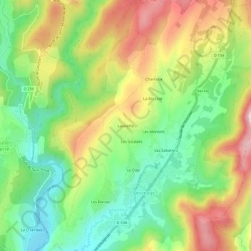
Name: Lauberte topographic map, elevation, terrain.
Average elevation: 373 m
Minimum elevation: 222 m
Maximum elevation: 573 m
Other topographic maps
Click on a map to view its topography, its elevation and its terrain.
Les Sabatiers
France > Auvergne-Rhône-Alpes > Ardèche > Vesseaux
Les Sabatiers, Vesseaux, Largentière, Ardèche, Auvergne-Rhône-Alpes, France métropolitaine, 07200, France
Average elevation: 390 m
Le Clap
France > Auvergne-Rhône-Alpes > Ardèche > Vesseaux
Le Clap, Vesseaux, Largentière, Ardèche, Auvergne-Rhône-Alpes, France métropolitaine, 07200, France
Average elevation: 361 m