Thank you for supporting this site ❤️
Make a donation
Make a donation
Cold Higham topographic map
Click on the map to display elevation.
Thank you for supporting this site ❤️
Make a donation
Make a donation
About this map
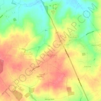
Name: Cold Higham topographic map, elevation, terrain.
Location: Cold Higham, West Northamptonshire, England, United Kingdom (52.15998 -1.06399 52.19566 -1.02262)
Average elevation: 131 m
Minimum elevation: 89 m
Maximum elevation: 165 m
Thank you for supporting this site ❤️
Make a donation
Make a donation
Other topographic maps
Click on a map to view its topography, its elevation and its terrain.
Ravensthorpe Reservoir
United Kingdom > England > West Northamptonshire > Coton
Average elevation: 131 m
Thank you for supporting this site ❤️
Make a donation
Make a donation
Thank you for supporting this site ❤️
Make a donation
Make a donation
Thank you for supporting this site ❤️
Make a donation
Make a donation
Thank you for supporting this site ❤️
Make a donation
Make a donation
Lower Thorpe
United Kingdom > England > West Northamptonshire > Thorpe Mandeville
Average elevation: 154 m
Thank you for supporting this site ❤️
Make a donation
Make a donation
Thank you for supporting this site ❤️
Make a donation
Make a donation
Thank you for supporting this site ❤️
Make a donation
Make a donation
Thank you for supporting this site ❤️
Make a donation
Make a donation
Thank you for supporting this site ❤️
Make a donation
Make a donation
