
Thank you for supporting this site ❤️
Make a donation
Make a donation
La Estación topographic map
Click on the map to display elevation.
Thank you for supporting this site ❤️
Make a donation
Make a donation
About this map
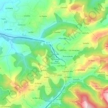
Name: La Estación topographic map, elevation, terrain.
Location: La Estación, Siero, Asturias, 33936, España (43.33188 -5.65572 43.37188 -5.61572)
Average elevation: 340 m
Minimum elevation: 218 m
Maximum elevation: 541 m
Thank you for supporting this site ❤️
Make a donation
Make a donation
Other topographic maps
Click on a map to view its topography, its elevation and its terrain.