
Thank you for supporting this site ❤️
Make a donation
Make a donation
Derby topographic map
Click on the map to display elevation.
Thank you for supporting this site ❤️
Make a donation
Make a donation
About this map
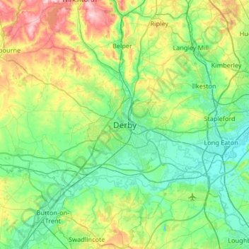
Name: Derby topographic map, elevation, terrain.
Location: Derby, Derbyshire, England, DE1 2AA, United Kingdom (52.76126 -1.63615 53.08126 -1.31615)
Average elevation: 96 m
Minimum elevation: 25 m
Maximum elevation: 315 m
Thank you for supporting this site ❤️
Make a donation
Make a donation
Other topographic maps
Click on a map to view its topography, its elevation and its terrain.
Longford CP
United Kingdom > England > Derbyshire > Derbyshire Dales > Longford CP
Average elevation: 94 m