
Make a donation
Dar es-Salaam topographic map
Click on the map to display elevation.
Make a donation
About this map
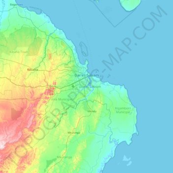
Name: Dar es-Salaam topographic map, elevation, terrain.
Location: Dar es-Salaam, Coastal Zone, Tanzania (-7.18684 39.00703 -6.56620 39.92805)
Average elevation: 57 m
Minimum elevation: 0 m
Maximum elevation: 387 m
Make a donation
Other topographic maps
Click on a map to view its topography, its elevation and its terrain.
Kilimanjaro
Mount Kilimanjaro (/ˌkɪlɪmənˈdʒɑːroʊ/) is a dormant volcano in Tanzania. It is the highest mountain in Africa and the highest free-standing mountain above sea level in the world: 5,895 m (19,341 ft) above sea level and 4,900 m (16,100 ft) above its plateau base. It is also the highest volcano in the…
Average elevation: 1,537 m
Mbeya
Mbeya is situated at an altitude of 1,700 metres (5,500 ft), and sprawls through a narrow highland valley surrounded by a bowl of high mountains. The main language is colloquial Swahili, and the English language is extensively taught in schools.
Average elevation: 1,817 m
Arusha
Despite its proximity to the equator, Arusha's elevation of 1,400 metres (4,600 ft) on the southern slopes of Mount Meru keeps temperatures relatively low and alleviates humidity. Cool dry air is prevalent for much of the year. The temperature typically ranges between 10 and 30 °C (50 and 86 °F) with an…
Average elevation: 1,572 m
Kilimanjaro
Mount Kilimanjaro (/ˌkɪlɪmənˈdʒɑːroʊ/) is a dormant volcano in Tanzania. It is the highest mountain in Africa and the highest free-standing mountain above sea level in the world: 5,895 m (19,341 ft) above sea level and 4,900 m (16,100 ft) above its plateau base. It is also the highest volcano in the…
Average elevation: 1,537 m
Make a donation
Make a donation
Make a donation
Make a donation
Make a donation
Lake Chala
Lake Chala's average annual rainfall is about 565 millimetres (22.2 in). The lake surface has an average annual evaporation of near 1,735 millimetres (68.3 in). Approximately 80 percent of the lake's inflow comes from groundwater, which is derived mostly from rainfall in the montane forest zone of Mount…
Average elevation: 900 m
Mbeya
Mbeya is situated at an altitude of 1,700 metres (5,500 ft), and sprawls through a narrow highland valley surrounded by a bowl of high mountains. The main language is colloquial Swahili, and the English language is extensively taught in schools.
Average elevation: 1,817 m
Make a donation
Mbeya
Mbeya is situated at an altitude of 1,700 metres (5,500 ft), and sprawls through a narrow highland valley surrounded by a bowl of high mountains. The main language is colloquial Swahili, and the English language is extensively taught in schools.
Average elevation: 1,817 m
Make a donation
Make a donation
Make a donation
Mutukula
The town of Mutukula is a border town between Uganda and Tanzania. At an altitude of 1,190 metres (3,900 ft), above sea level, Mutukula is an important border post and major crossing point, for both human and commercial traffic. In February 2016, the border post between both countries merged operations on both…
Average elevation: 1,181 m
Make a donation
Kilimanjaro
Kilimanjaro is the fourth most topographically prominent peak on Earth. It is part of Kilimanjaro National Park and is a major hiking and climbing destination. Because of its shrinking glaciers and ice fields, which are projected to disappear between 2025 and 2035, it has been the subject of many scientific…
Average elevation: 1,537 m
Make a donation
Make a donation
Make a donation
Make a donation
Make a donation
Kilimanjaro
Mount Kilimanjaro (/ˌkɪlɪmənˈdʒɑːroʊ/) is a dormant volcano in Tanzania. It is the highest mountain in Africa and the highest free-standing mountain above sea level in the world, at 5,895 m (19,341 ft) above sea level and 4,900 m (16,100 ft) above its plateau base. It is also the highest volcano in…
Average elevation: 1,537 m
Make a donation
Make a donation
Make a donation
Make a donation
Make a donation
Kilimanjaro
Kilimanjaro is the fourth most topographically prominent peak on Earth. It is part of Kilimanjaro National Park and is a major hiking and climbing destination. Because of its shrinking glaciers and ice fields, which are projected to disappear between 2025 and 2035, it has been the subject of many scientific…
Average elevation: 1,537 m
Make a donation
Make a donation
Kilimanjaro
Mount Kilimanjaro (/ˌkɪlɪmənˈdʒɑːroʊ/) is a dormant volcano in Tanzania. It is the highest mountain in Africa and the highest free-standing mountain above sea level in the world, situated at 5,895 m (19,341 ft) above sea level and 4,900 m (16,100 ft) above its plateau base. It is also the highest…
Average elevation: 1,537 m
Make a donation
Make a donation
Make a donation