
Thank you for supporting this site ❤️
Make a donation
Make a donation
Hill Point topographic map
Click on the map to display elevation.
Thank you for supporting this site ❤️
Make a donation
Make a donation
About this map
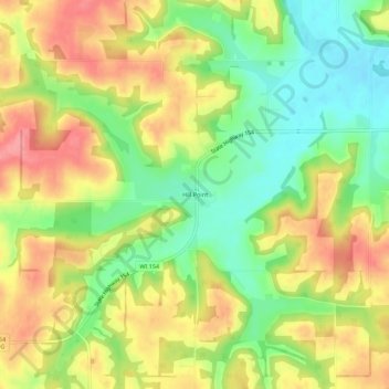
Name: Hill Point topographic map, elevation, terrain.
Average elevation: 331 m
Minimum elevation: 284 m
Maximum elevation: 378 m
Thank you for supporting this site ❤️
Make a donation
Make a donation
Other topographic maps
Click on a map to view its topography, its elevation and its terrain.
Devil's Lake State Park
United States > Wisconsin > Sauk County > Town of Baraboo
Average elevation: 335 m
Thank you for supporting this site ❤️
Make a donation
Make a donation
Parfrey's Glen State Natural Area
United States > Wisconsin > Sauk County > Town of Merrimac
Average elevation: 360 m
Thank you for supporting this site ❤️
Make a donation
Make a donation
Thank you for supporting this site ❤️
Make a donation
Make a donation
Dells of the Wisconsin River State Natural Area
United States > Wisconsin > Sauk County > Wisconsin Dells
Average elevation: 282 m
Thank you for supporting this site ❤️
Make a donation
Make a donation