
Thank you for supporting this site ❤️
Make a donation
Make a donation
Lake Clark topographic map
Click on the map to display elevation.
Thank you for supporting this site ❤️
Make a donation
Make a donation
About this map
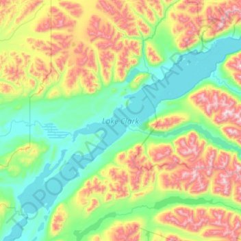
Name: Lake Clark topographic map, elevation, terrain.
Average elevation: 477 m
Minimum elevation: 72 m
Maximum elevation: 1,601 m
Thank you for supporting this site ❤️
Make a donation
Make a donation
Other topographic maps
Click on a map to view its topography, its elevation and its terrain.
Thank you for supporting this site ❤️
Make a donation
Make a donation
Mount Aniakchak
United States > Alaska > Lake and Peninsula Borough
Milky-green Surprise Lake has an area of 2.75 square kilometers (1.06 sq mi) and abuts the inner northeastern margin of the caldera. Its water is about 19.5 meters (64 ft) deep and originates from various hot springs, cold springs and meltwater. Lake waters are continually mixed by strong winds. Hydrothermal…
Average elevation: 483 m