
Brandywine topographic map
Interactive map
Click on the map to display elevation.
About this map
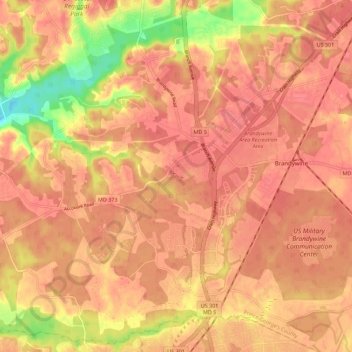
Name: Brandywine topographic map, elevation, terrain.
Average elevation: 61 m
Minimum elevation: 11 m
Maximum elevation: 78 m
Other topographic maps
Click on a map to view its topography, its elevation and its terrain.
National Harbor
United States > Maryland > Prince George's County
National Harbor, Prince George's County, Maryland, 20745, United States
Average elevation: 24 m
College Park
United States > Maryland > Prince George's County
College Park, Prince George's County, Maryland, United States
Average elevation: 38 m
Auth Village
United States > Maryland > Prince George's County > Camp Springs
Auth Village, Camp Springs, Prince George's County, Maryland, 20746, United States
Average elevation: 77 m
Mount Rainier
United States > Maryland > Prince George's County
Mount Rainier, Prince George's County, Maryland, 20712, United States
Average elevation: 20 m
Beltsville
United States > Maryland > Prince George's County
Beltsville, Prince George's County, Maryland, 20705, United States
Average elevation: 55 m
Wildercroft
United States > Maryland > Prince George's County > East Riverdale
Wildercroft, East Riverdale, Prince George's County, Maryland, 20052, United States
Average elevation: 39 m
Rosaryville State Park
United States > Maryland > Prince George's County > Upper Marlboro
Rosaryville State Park, 7805, Upper Marlboro, Prince George's County, Maryland, 20735, United States
Average elevation: 59 m
Hyattsville
United States > Maryland > Prince George's County
Hyattsville, Prince George's County, Maryland, 20781, United States
Average elevation: 61 m
Glenn Dale
United States > Maryland > Prince George's County
Glenn Dale, Prince George's County, Maryland, 20769, United States
Average elevation: 51 m
Forestville
United States > Maryland > Prince George's County
Forestville, Prince George's County, Maryland, 20747, United States
Average elevation: 71 m
Fort Washington
United States > Maryland > Prince George's County
Fort Washington, Prince George's County, Maryland, 20607, United States
Average elevation: 26 m
Cottage City
United States > Maryland > Prince George's County
Cottage City, Prince George's County, Maryland, United States
Average elevation: 17 m
Camp Springs
United States > Maryland > Prince George's County
Camp Springs, Prince George's County, Maryland, 20762, United States
Average elevation: 75 m
Lake Arbor
United States > Maryland > Prince George's County
Lake Arbor, Prince George's County, Maryland, United States
Average elevation: 46 m
Coral Hills
United States > Maryland > Prince George's County
Coral Hills, Prince George's County, Maryland, 20743, United States
Average elevation: 69 m
Croom
United States > Maryland > Prince George's County
Croom, Prince George's County, Maryland, United States
Average elevation: 47 m
Andrews Manor
United States > Maryland > Prince George's County > Camp Springs
Andrews Manor, Camp Springs, Prince George's County, Maryland, 20762, United States
Average elevation: 79 m
Berwyn Heights
United States > Maryland > Prince George's County
Berwyn Heights, Prince George's County, Maryland, United States
Average elevation: 33 m
Mellwood
United States > Maryland > Prince George's County
Mellwood, Prince George's County, Maryland, 20772, United States
Average elevation: 60 m
District Heights
United States > Maryland > Prince George's County
District Heights, Prince George's County, Maryland, 20747, United States
Average elevation: 77 m
Phelps Corner
United States > Maryland > Prince George's County > Oxon Hill
Phelps Corner, Oxon Hill, Prince George's County, Maryland, 20745, United States
Average elevation: 58 m
West Laurel
United States > Maryland > Prince George's County > West Laurel
West Laurel, Prince George's County, Maryland, United States
Average elevation: 101 m
Bowie
United States > Maryland > Prince George's County
Bowie, Prince George's County, Maryland, United States
Average elevation: 38 m
Laurel
United States > Maryland > Prince George's County
Laurel, Prince George's County, Maryland, 20707, United States
Average elevation: 73 m
Eagle Harbor
United States > Maryland > Prince George's County
Eagle Harbor, Prince George's County, Maryland, United States
Average elevation: 13 m
Chestnut Hills
United States > Maryland > Prince George's County > Beltsville
Chestnut Hills, Beltsville, Prince George's County, Maryland, 20705, United States
Average elevation: 47 m
Brentwood
United States > Maryland > Prince George's County
Brentwood, Prince George's County, Maryland, 20722, United States
Average elevation: 17 m
Forestville
United States > Maryland > Prince George's County > Forestville
Forestville, Prince George's County, Maryland, United States
Average elevation: 73 m
Edmonston
United States > Maryland > Prince George's County
Edmonston, Prince George's County, Maryland, 20781, United States
Average elevation: 21 m
The Village
United States > Maryland > Prince George's County > Brandywine
The Village, Brandywine, Prince George's County, Maryland, 20613, United States
Average elevation: 68 m
White Hall
United States > Maryland > Prince George's County > Accokeek
White Hall, Accokeek, Prince George's County, Maryland, 20607, United States
Average elevation: 36 m
Upper Marlboro
United States > Maryland > Prince George's County
Upper Marlboro, Prince George's County, Maryland, United States
Average elevation: 22 m
Mount Rainier Community Food Forest
United States > Maryland > Prince George's County > Mount Rainier
Mount Rainier Community Food Forest, Kaywood Gardens, Mount Rainier, Prince George's County, Maryland, United States
Average elevation: 23 m
Camp Springs
United States > Maryland > Prince George's County > Camp Springs
Camp Springs, Prince George's County, Maryland, 20746, United States
Average elevation: 72 m
University Park
United States > Maryland > Prince George's County > University Park
University Park, Prince George's County, Maryland, United States
Average elevation: 29 m
Lake Artemesia
United States > Maryland > Prince George's County > College Park
Lake Artemesia, Lakeland, College Park, Prince George's County, Maryland, United States
Average elevation: 26 m
Beltsville
United States > Maryland > Prince George's County > Beltsville
Beltsville, Prince George's County, Maryland, 20705, United States
Average elevation: 61 m
Lanham
United States > Maryland > Prince George's County > Glenn Dale
Lanham, Glenn Dale, Prince George's County, Maryland, 20706, United States
Average elevation: 47 m
Adelphi
United States > Maryland > Prince George's County > Adelphi
Adelphi, Prince George's County, Maryland, United States
Average elevation: 56 m
Leeland
United States > Maryland > Prince George's County > Leeland
Leeland, Prince George's County, Maryland, United States
Average elevation: 35 m
Seabrook Acres
United States > Maryland > Prince George's County > Seabrook > Seabrook Acres
Seabrook Acres, Seabrook, Prince George's County, Maryland, 20706, United States
Average elevation: 50 m
Oxon Hill
United States > Maryland > Prince George's County > Oxon Hill
Oxon Hill, Prince George's County, Maryland, 20745, United States
Average elevation: 54 m
Hyattsville
United States > Maryland > Prince George's County
Hyattsville, Prince George's County, Maryland, 20782, United States
Average elevation: 24 m
Greater Capitol Heights
United States > Maryland > Prince George's County > Maryland Park > Greater Capitol Heights
Greater Capitol Heights, Capitol Heights, Maryland Park, Prince George's County, Maryland, 20743, United States
Average elevation: 59 m
District Heights
United States > Maryland > Prince George's County > District Heights > District Heights
District Heights, Prince George's County, Maryland, 20747, United States
Average elevation: 73 m
Landover
United States > Maryland > Prince George's County > Landover
Landover, Prince George's County, Maryland, 20785, United States
Average elevation: 38 m
Chillum
United States > Maryland > Prince George's County > Chillum
Chillum, Prince George's County, Maryland, United States
Average elevation: 43 m
Piscataway
United States > Maryland > Prince George's County > Piscataway
Piscataway, Prince George's County, Maryland, 20607, United States
Average elevation: 36 m
Aquasco
United States > Maryland > Prince George's County > Aquasco
Aquasco, Prince George's County, Maryland, 20608, United States
Average elevation: 28 m
Laurel
United States > Maryland > Prince George's County > Laurel
Laurel, Prince George's County, Maryland, 20707, United States
Average elevation: 82 m