
Thank you for supporting this site ❤️
Make a donation
Make a donation
Central Islip topographic map
Click on the map to display elevation.
Thank you for supporting this site ❤️
Make a donation
Make a donation
About this map
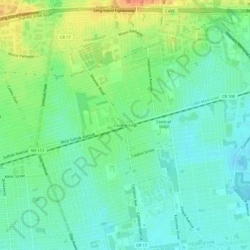
Name: Central Islip topographic map, elevation, terrain.
Average elevation: 26 m
Minimum elevation: 11 m
Maximum elevation: 54 m
Thank you for supporting this site ❤️
Make a donation
Make a donation
Other topographic maps
Click on a map to view its topography, its elevation and its terrain.
Robert Moses State Park (Long Island)
United States > New York > Suffolk County > Town of Islip
Average elevation: 0 m
Village of Brightwaters
United States > New York > Suffolk County > Town of Islip
Average elevation: 8 m