
Thank you for supporting this site ❤️
Make a donation
Make a donation
Fair Plain topographic map
Click on the map to display elevation.
Thank you for supporting this site ❤️
Make a donation
Make a donation
About this map
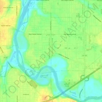
Name: Fair Plain topographic map, elevation, terrain.
Average elevation: 190 m
Minimum elevation: 174 m
Maximum elevation: 207 m
Thank you for supporting this site ❤️
Make a donation
Make a donation
Other topographic maps
Click on a map to view its topography, its elevation and its terrain.
Thank you for supporting this site ❤️
Make a donation
Make a donation
Gordon Beach
United States > Michigan > Berrien County > New Buffalo Township > Gordon Beach
Average elevation: 183 m
Thank you for supporting this site ❤️
Make a donation
Make a donation