
Thank you for supporting this site ❤️
Make a donation
Make a donation
Mountview topographic map
Click on the map to display elevation.
Thank you for supporting this site ❤️
Make a donation
Make a donation
About this map
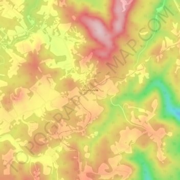
Name: Mountview topographic map, elevation, terrain.
Average elevation: 893 m
Minimum elevation: 735 m
Maximum elevation: 994 m
Thank you for supporting this site ❤️
Make a donation
Make a donation
Other topographic maps
Click on a map to view its topography, its elevation and its terrain.
Beckley
United States > West Virginia > Raleigh County
Due to its elevation, the climate of Beckley is humid subtropical (Köppen Cfa) bordering on both an oceanic (Köppen Cfb) and humid continental (Köppen Dfa/Dfb), and the city straddles the border between USDA Plant Hardiness Zones 6B and 7A. Summers are warm and humid, usually a few degrees cooler than…
Average elevation: 723 m