
Make a donation
Red Lake topographic map
Click on the map to display elevation.
Make a donation
About this map
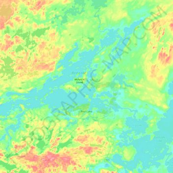
Name: Red Lake topographic map, elevation, terrain.
Average elevation: 382 m
Minimum elevation: 352 m
Maximum elevation: 461 m
Make a donation
Other topographic maps
Click on a map to view its topography, its elevation and its terrain.
Slate Islands
Canada > Ontario > Kenora District > Unorganized Kenora District
Average elevation: 322 m
Galbraith Lake
Canada > Ontario > Kenora District > Unorganized Kenora District
Average elevation: 455 m
Make a donation
Loveland Lake
Canada > Ontario > Kenora District > Unorganized Kenora District
Average elevation: 426 m
Make a donation
Banana Island
Canada > Ontario > Kenora District > Unorganized Kenora District
Average elevation: 359 m
Ghost Island
Canada > Ontario > Kenora District > Unorganized Kenora District
Average elevation: 401 m
Make a donation
Forbes Lake
Canada > Ontario > Kenora District > Sioux Narrows-Nestor Falls Township
Average elevation: 373 m
Sioux Narrows
Canada > Ontario > Kenora District > Sioux Narrows-Nestor Falls Township
Average elevation: 329 m
Make a donation