
Thank you for supporting this site ❤️
Make a donation
Make a donation
Fuejo topographic map
Click on the map to display elevation.
Thank you for supporting this site ❤️
Make a donation
Make a donation
About this map
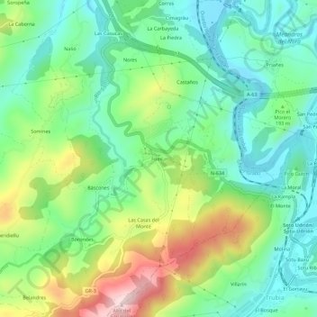
Name: Fuejo topographic map, elevation, terrain.
Location: Fuejo, Báscones, Grado, Asturias, 33825, España (43.34403 -6.00938 43.38403 -5.96938)
Average elevation: 178 m
Minimum elevation: 58 m
Maximum elevation: 421 m
Thank you for supporting this site ❤️
Make a donation
Make a donation
Other topographic maps
Click on a map to view its topography, its elevation and its terrain.