
Thank you for supporting this site ❤️
Make a donation
Make a donation
Pico Curueza topographic map
Click on the map to display elevation.
Thank you for supporting this site ❤️
Make a donation
Make a donation
About this map
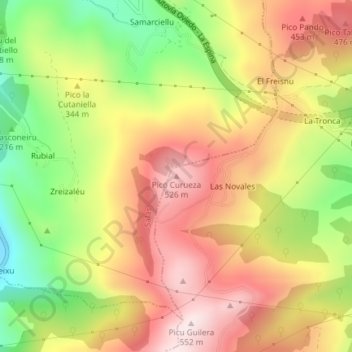
Name: Pico Curueza topographic map, elevation, terrain.
Location: Pico Curueza, Grado, Asturias, 33858, España (43.37835 -6.13197 43.37845 -6.13187)
Average elevation: 326 m
Minimum elevation: 66 m
Maximum elevation: 545 m
Thank you for supporting this site ❤️
Make a donation
Make a donation
Other topographic maps
Click on a map to view its topography, its elevation and its terrain.