
Thank you for supporting this site ❤️
Make a donation
Make a donation
Lozère topographic map
Click on the map to display elevation.
Thank you for supporting this site ❤️
Make a donation
Make a donation
About this map
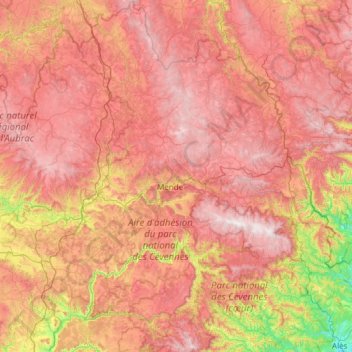
Name: Lozère topographic map, elevation, terrain.
Location: Lozère, Occitania, Metropolitan France, France (44.10934 2.98226 44.97578 3.99836)
Average elevation: 958 m
Minimum elevation: 122 m
Maximum elevation: 1,697 m
Thank you for supporting this site ❤️
Make a donation
Make a donation