
鲁山县 topographic map
Interactive map
Click on the map to display elevation.
About this map
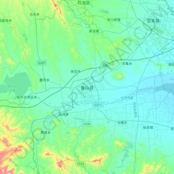
Name: 鲁山县 topographic map, elevation, terrain.
Location: 鲁山县, 平顶山市, 河南省, 中国 (33.58349 112.74834 33.90349 113.06834)
Average elevation: 184 m
Minimum elevation: 101 m
Maximum elevation: 660 m
Other topographic maps
Click on a map to view its topography, its elevation and its terrain.
河南省安阳师范学院家属院-家
河南省安阳师范学院家属院-家, 平原路, 紫薇大道街道, 开发区银杏大街街道, 文峰区, 安阳市, 河南省, 455000, 中国
Average elevation: 69 m