
Thank you for supporting this site ❤️
Make a donation
Make a donation
Lecce topographic map
Click on the map to display elevation.
Thank you for supporting this site ❤️
Make a donation
Make a donation
About this map
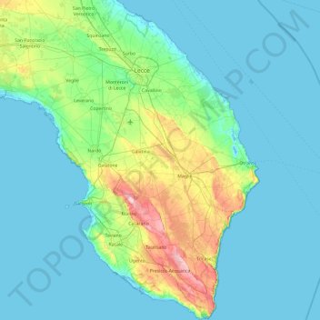
Name: Lecce topographic map, elevation, terrain.
Location: Lecce, Apulia, Italy (39.78959 17.76246 40.51487 18.52051)
Average elevation: 29 m
Minimum elevation: -4 m
Maximum elevation: 197 m
Thank you for supporting this site ❤️
Make a donation
Make a donation
Other topographic maps
Click on a map to view its topography, its elevation and its terrain.