
Make a donation
Dexter topographic map
Click on the map to display elevation.
Make a donation
About this map
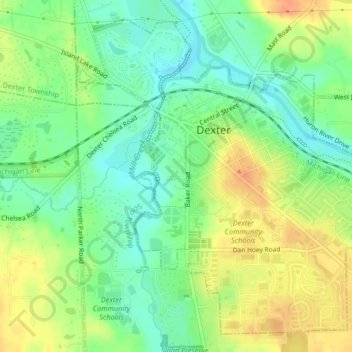
Name: Dexter topographic map, elevation, terrain.
Location: Dexter, Washtenaw County, Michigan, 48130, United States (42.31957 -83.90017 42.34699 -83.85887)
Average elevation: 270 m
Minimum elevation: 252 m
Maximum elevation: 290 m
Make a donation
Other topographic maps
Click on a map to view its topography, its elevation and its terrain.
Rawsonville
United States > Michigan > Washtenaw County > Ypsilanti Charter Township
Average elevation: 214 m
Rawsonville
United States > Michigan > Washtenaw County > Ypsilanti Charter Township
Average elevation: 214 m
Mooreville
United States > Michigan > Washtenaw County > York Charter Township
Average elevation: 222 m
Make a donation
Rawsonville
United States > Michigan > Washtenaw County > Ypsilanti Charter Township
Average elevation: 214 m
Frain Lake
United States > Michigan > Washtenaw County > Superior Charter Township
Average elevation: 259 m