
Thank you for supporting this site ❤️
Make a donation
Make a donation
Lemon Hill topographic map
Click on the map to display elevation.
Thank you for supporting this site ❤️
Make a donation
Make a donation
About this map
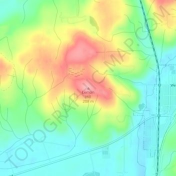
Name: Lemon Hill topographic map, elevation, terrain.
Average elevation: 123 m
Minimum elevation: 74 m
Maximum elevation: 201 m
Thank you for supporting this site ❤️
Make a donation
Make a donation
Other topographic maps
Click on a map to view its topography, its elevation and its terrain.
Mima Mounds Natural Area Preserve
United States > Washington > Thurston County
Average elevation: 62 m