
Thank you for supporting this site ❤️
Make a donation
Make a donation
Muneng topographic map
Click on the map to display elevation.
Thank you for supporting this site ❤️
Make a donation
Make a donation
About this map
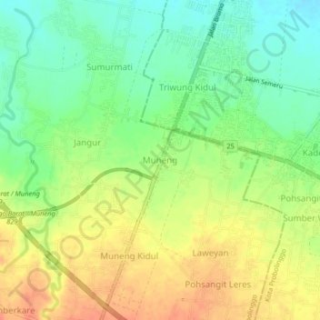
Name: Muneng topographic map, elevation, terrain.
Location: Muneng, Probolinggo, East Java, Java, 67231, Indonesia (-7.80407 113.14633 -7.76407 113.18633)
Average elevation: 35 m
Minimum elevation: 12 m
Maximum elevation: 58 m
Thank you for supporting this site ❤️
Make a donation
Make a donation
Other topographic maps
Click on a map to view its topography, its elevation and its terrain.
Suaka Margasatwa Dataran Tinggi Yang
Indonesia > East Java > Probolinggo > Situbondo
Average elevation: 1,885 m