
Thank you for supporting this site ❤️
Make a donation
Make a donation
Tracy Creek topographic map
Click on the map to display elevation.
Thank you for supporting this site ❤️
Make a donation
Make a donation
About this map
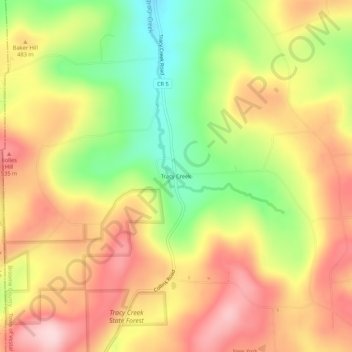
Name: Tracy Creek topographic map, elevation, terrain.
Average elevation: 453 m
Minimum elevation: 317 m
Maximum elevation: 568 m
Thank you for supporting this site ❤️
Make a donation
Make a donation
Other topographic maps
Click on a map to view its topography, its elevation and its terrain.
State University of New York at Binghamton
United States > New York > Broome County > Town of Vestal
Average elevation: 320 m
Kopernik Observatory & Science Center
United States > New York > Broome County > Town of Vestal > Tracy Creek
Average elevation: 452 m