
Make a donation
Cortland County topographic map
Click on the map to display elevation.
Make a donation
About this map
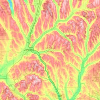
Name: Cortland County topographic map, elevation, terrain.
Location: Cortland County, New York, United States (42.40765 -76.27460 42.79104 -75.86416)
Average elevation: 453 m
Minimum elevation: 261 m
Maximum elevation: 648 m
Make a donation
Other topographic maps
Click on a map to view its topography, its elevation and its terrain.
Make a donation
Make a donation
Chester Heights
United States > New York > Westchester County > City of New Rochelle
Average elevation: 36 m
Make a donation
Black Creek Village
United States > New York > Niagara County > City of Niagara Falls
Average elevation: 176 m
Make a donation
West Point
United States > New York > Suffolk County > Hampton Bays > Town of Southampton > Rampasture
Average elevation: 3 m
Make a donation
Dutch Settlement
United States > New York > Oswego County > Town of West Monroe
Average elevation: 148 m
Make a donation
Lower Bridal Veil Falls
United States > New York > Greene County > Town of Hunter
Average elevation: 620 m
Make a donation
Albany
United States > New York > Albany County > Albany
The highest natural point in Albany is a USGS benchmark near the Loudonville Reservoir off Birch Hill Road, at 378 feet (115 m) above sea level. The lowest point is sea level at the Hudson River (the average water elevation is 2 feet (0.61 m)), which is still technically an estuary at Albany and is affected by…
Average elevation: 114 m
Make a donation
Make a donation
Clinton Heights
United States > New York > Rensselaer County > Clinton Heights
Average elevation: 49 m
Make a donation
Malone Junction
United States > New York > Franklin County > Malone > Malone Junction
Average elevation: 233 m
Bonny Hill
United States > New York > Steuben County > Town of Thurston > Bonny Hill
Average elevation: 488 m
Make a donation
Make a donation