
Thank you for supporting this site ❤️
Make a donation
Make a donation
El Cerrito topographic map
Click on the map to display elevation.
Thank you for supporting this site ❤️
Make a donation
Make a donation
El Cerrito
According to the United States Census Bureau, the city has a total area of 3.7 square miles (9.6 km2), all of it land. The city ranges in elevation from 20 to 934 feet, with an average elevation of 69 feet (21 m).
Thank you for supporting this site ❤️
Make a donation
Make a donation
About this map
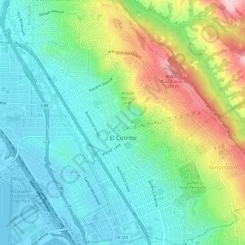
Name: El Cerrito topographic map, elevation, terrain.
Average elevation: 91 m
Minimum elevation: -1 m
Maximum elevation: 307 m
Thank you for supporting this site ❤️
Make a donation
Make a donation