
Thank you for supporting this site ❤️
Make a donation
Make a donation
Quinçay topographic map
Click on the map to display elevation.
Thank you for supporting this site ❤️
Make a donation
Make a donation
Quinçay
La forêt de Vouillé est située tout près de la commune de Quinçay. C'est un important massif domanial de 1 500 hectares. Elle couvre un plateau à topographie très plane et d'altitude modeste : entre 130 m et 140 m en moyenne.
Thank you for supporting this site ❤️
Make a donation
Make a donation
About this map
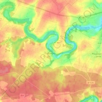
Name: Quinçay topographic map, elevation, terrain.
Average elevation: 123 m
Minimum elevation: 79 m
Maximum elevation: 149 m
Thank you for supporting this site ❤️
Make a donation
Make a donation
Other topographic maps
Click on a map to view its topography, its elevation and its terrain.
Châtellerault
France > Nouvelle-Aquitaine > Vienne > Châtellerault > Châtellerault
Average elevation: 79 m
Thank you for supporting this site ❤️
Make a donation
Make a donation