
Make a donation
Snelling topographic map
Click on the map to display elevation.
Make a donation
About this map
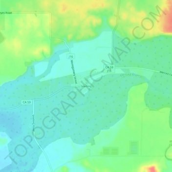
Name: Snelling topographic map, elevation, terrain.
Location: Snelling, Merced County, California, 95369, United States (37.49910 -120.45742 37.53910 -120.41742)
Average elevation: 88 m
Minimum elevation: 71 m
Maximum elevation: 125 m
Make a donation
Other topographic maps
Click on a map to view its topography, its elevation and its terrain.
Los Banos
United States > California > Merced County
Los Banos is located on the west side of the San Joaquin Valley, 26 miles (42 km) southwest of Merced, at about 118 ft (36 m) elevation. Its coordinates are 37°03′30″N 120°51′00″W / 37.05833°N 120.85000°W / 37.05833; -120.85000. The city is at the intersection of California State Route 152…
Average elevation: 36 m
Atwater
United States > California > Merced County
Atwater is a city on State Route 99 in Merced County, California, United States. Atwater is 8 miles (13 km) west-northwest of Merced, at an elevation of 151 feet (46 m). The population as of the 2020 census was 31,970, up from 28,168 in 2010.
Average elevation: 50 m
Winton
United States > California > Merced County
Winton (formerly, Merced Colony No. 1, Merced Colony No. 2, and Windfield) is a census-designated place (CDP) in Merced County, California, United States. Winton is located 2.5 miles (4 km) north of Atwater, at an elevation of 177 feet (54 m). The population was 10,613 at the 2010 census, up from 8,832 at the…
Average elevation: 54 m
Gustine
United States > California > Merced County > Gustine
Gustine is a city in Merced County, California, United States. Gustine is located 29 miles (47 km) west of Merced, at an elevation of 98 feet (30 m). At the 2010 census, the city population was 5,520, up from 4,698 at the 2000 census.
Average elevation: 30 m
Make a donation