
Chartreuse topographic map
Interactive map
Click on the map to display elevation.
About this map
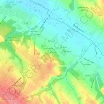
Name: Chartreuse topographic map, elevation, terrain.
Average elevation: 159 m
Minimum elevation: 126 m
Maximum elevation: 209 m
Other topographic maps
Click on a map to view its topography, its elevation and its terrain.
La Couanche
France > Occitanie > Haute-Garonne > Montberon
La Couanche, Montberon, Toulouse, Haute-Garonne, Occitanie, France métropolitaine, 31140, France
Average elevation: 158 m