
Niger topographic map
Interactive map
Click on the map to display elevation.
Niger
The lowest point is the Niger River, with an elevation of 200 metres (656 ft). The highest point is Mont Idoukal-n-Taghès in the Aïr Mountains at 2,022 m (6,634 ft).
About this map
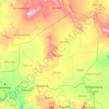
Name: Niger topographic map, elevation, terrain.
Location: Niger (11.69361 0.16897 23.51718 15.99667)
Average elevation: 518 m
Minimum elevation: 137 m
Maximum elevation: 2,672 m