
Thank you for supporting this site ❤️
Make a donation
Make a donation
Umčani topographic map
Click on the map to display elevation.
Thank you for supporting this site ❤️
Make a donation
Make a donation
About this map
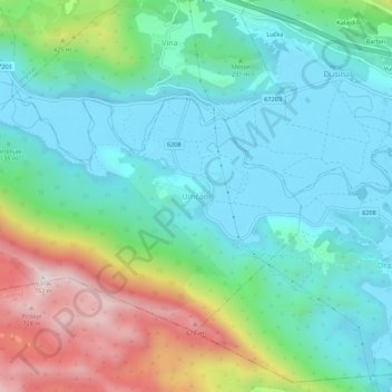
Name: Umčani topographic map, elevation, terrain.
Location: Umčani, Grad Vrgorac, Split-Dalmatia County, 21276, Croatia (43.14534 17.36728 43.18534 17.40728)
Average elevation: 222 m
Minimum elevation: 21 m
Maximum elevation: 752 m
Thank you for supporting this site ❤️
Make a donation
Make a donation
Other topographic maps
Click on a map to view its topography, its elevation and its terrain.
Thank you for supporting this site ❤️
Make a donation
Make a donation
Hvar
Croatia > Split-Dalmatia County
The island has a typical Mediterranean vegetation, mostly bare with woody scrub at higher, steeper elevations, turning to pine forests on the lower slopes with Holm oak (Orno-Quercetum ilicis), Aleppo pines (Pinus halapensis Mill) and Black pines (Pinus nigra dalmatica). The islet of Šćedro is especially…
Average elevation: 58 m
Thank you for supporting this site ❤️
Make a donation
Make a donation