
Thank you for supporting this site ❤️
Make a donation
Make a donation
La Comba topographic map
Click on the map to display elevation.
Thank you for supporting this site ❤️
Make a donation
Make a donation
About this map
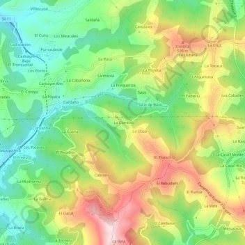
Name: La Comba topographic map, elevation, terrain.
Location: La Comba, Siero, Asturias, 33936, España (43.31913 -5.63273 43.35913 -5.59273)
Average elevation: 427 m
Minimum elevation: 243 m
Maximum elevation: 686 m
Thank you for supporting this site ❤️
Make a donation
Make a donation
Other topographic maps
Click on a map to view its topography, its elevation and its terrain.