
Thank you for supporting this site ❤️
Make a donation
Make a donation
Ampang Tulak topographic map
Click on the map to display elevation.
Thank you for supporting this site ❤️
Make a donation
Make a donation
About this map
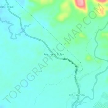
Name: Ampang Tulak topographic map, elevation, terrain.
Average elevation: 35 m
Minimum elevation: 9 m
Maximum elevation: 152 m
Thank you for supporting this site ❤️
Make a donation
Make a donation
Other topographic maps
Click on a map to view its topography, its elevation and its terrain.
Batang Air Bayang Gadang
Indonesia > West Sumatra > Pesisir Selatan > Pancuang Taba
Average elevation: 1,331 m
Thank you for supporting this site ❤️
Make a donation
Make a donation