
Thank you for supporting this site ❤️
Make a donation
Make a donation
Reabold Hill topographic map
Click on the map to display elevation.
Thank you for supporting this site ❤️
Make a donation
Make a donation
About this map
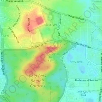
Name: Reabold Hill topographic map, elevation, terrain.
Location: Reabold Hill, Perth, Western Australia, 6015, Australia (-31.94051 115.77594 -31.94041 115.77604)
Average elevation: 32 m
Minimum elevation: 3 m
Maximum elevation: 82 m
Thank you for supporting this site ❤️
Make a donation
Make a donation
Other topographic maps
Click on a map to view its topography, its elevation and its terrain.